Sort by:


Grand Teton Day Hikes & National Park Map Map Pack Bundle
$24.95
The Tetons evoke a sense of inspiration and aspiration in all who visit. Established in 1929, Grand Teton National Park now encompasses and protects 310,000 acres (485 square miles) for...


Pocket Guide to:
$12.95
These pocket sized guides are easy to carry and packed full of useful information while on the trails.


Saratoga Springs Area Trail Map
$11.95
The Saratoga Springs Area Trail Map features the Wilton Wildlife Preserve and Park, Moreau Lake State Park, and Saratoga Spa State Park. It also includes cycling routes, hiking trails, mineral...


Schroon Lake Navigation Map
$11.95
The Schroon Lake Navigation Map is created for locals and visitors alike! This map highlights campgrounds, trails, and boat launches around Schroon Lake in great detail. With complete bathymetric...


Rainbow Lake Boating and Trails Map
$11.95
The Rainbow Lake Boating and Trails Map provides information on the campsites, trails, bathymetry, and boat launches across not only Rainbow Lake, but Lake Kushaqua, Clear Pond, and Buck Pond...


Zukes Hip Action Dog Treats 6oz
$15.99
Whether it’s a morning walk or a weekend hike, your dog’s favorite times are those spent exploring with you. Designed to fuel those adventures and keep the good times going...


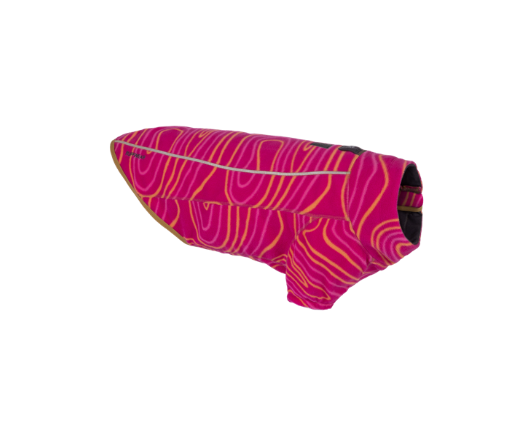
Lumenglow High-Vis Jacket - Closeout
The Lumenglow High-Vis Jacket boosts visibility of your dog in both daytime and low-light conditions. With reflective paneling that shines bright across all colorways, you can pick your color vibe...

Climate Changer Jacket - Closeout
The Climate Changer Jacket is a classic technical fleece that performs as hard as it plays. Recycled polyester fleece with sleeves and a full-length zipper is quick-drying and provides coverage...


Load Up Harness
$99.99
Answer the call of the open road with your No. 1 canine co-pilot and the Load Up Harness - an automotive canine travel harness designed to travel with dogs to...

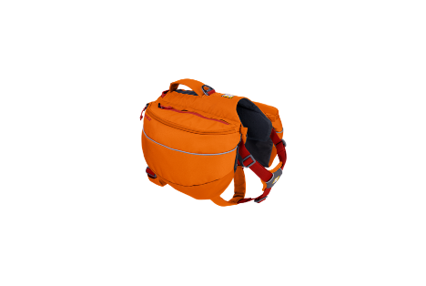
Approach Pack - Closeout
Roam further with the Approach Pack, a day hiking and light overnight dog pack with excellent performance, fit, and functionality. Radial cut saddlebags - sized right for extending day hikes...


Front Range Day Pack
$79.99
The Front Range Day Pack incorporates Ruffwear's signature radial cut saddlebags with the customer-favorite Front Range® Harness platform, making it an everyday pack staple in any dog's gear closet. Dogs...


The Northern Forest Canoe Trail Official Guide Book
$26.95
The Northern Forest Canoe Trail (NFCT) links the waterways of New York, Vermont, Quebec, New Hampshire, and Maine. This is the official guidebook to the whole 740-mile trail and reflects...